It has often been proposed to split California into two states. In the past, these proposals generally agreed on dividing Northern California from Southern California; the cultural differential between the two was strong in the Kennedy years. The reader may go to iTunes and check out Dick Dale’s instrumental version of “Misirlou,” an iconic anthem for Southern Californians who were young in that period, as I was; and then check out Vince Guaraldi’s jazz version of the same song, released virtually simultaneously with Dale’s in 1961. But more recently cultural differences have tended to arise more on a coastal-inland basis. For one thing, the climatic differences between San Francisco and Sacramento, and between San Diego and Riverside, are far sharper than those between San Francisco and San Diego, critical as the north-south difference is. For another, inland Northern California has turned increasingly conservative over time, whereas the secessio patriciorum of the late 60s and the 70s, in which much of the old Los Angeles elite fled to coastal Orange County, left Los Angeles much more under the domination of Hollywood than it had previously been. [My old private high school, Black-Foxe, had a very pro-Goldwater student body in 1964; it folded in 1968, a victim, I think, of the secessio patriciorum.]
In 2009, Bill Maze, a rural legislator disturbed that urbanites should tell his constituents how to raise chickens, offered a proposal to slice off a new state called Coastal California. But the boundary he proposed was a new one. Starting near Seal Beach, it sliced between Los Angeles and Orange Counties, then followed the Coast Ranges to the Bay Area, where it followed Carquinez Strait and then captured the wine and marijuana–growing counties north of Marin County for the rump California, excluding them from Coastal California. I can only suppose that he thought them agricultural enough to share his particular concerns. After all, it is for their agricultural products that those regions are known. The two coastal counties in the far south, Orange and San Diego, are also kept in rump California, not Coastal California, I suppose because they are the point of what I have heard called the ‘Fishhook’ – they are far more Republican than most of the coastal counties to the north of them. [Ventura County has a conservative streak, but its population is one tenth that of Orange and San Diego Counties combined.]
And then, in 2011, Jeff Stone, a Riverside County supervisor, proposed another division. He proposed to set off a ‘South California’ from the rest of the state. His line followed Maze’s from Seal Beach to near Ortigalita Mountain southeast of Hollister, but from that point it headed eastward across the San Joaquin Valley. Mr. Stone must really like to vacation in Yosemite Valley, for the line takes a distinct bulge in order to capture for South California the county in which it lies. It then captures the county in which Mammoth Lakes lies, but that’s not odd because three months of the year that county is inaccessible from the Bay Area or the San Joaquin Valley anyway.
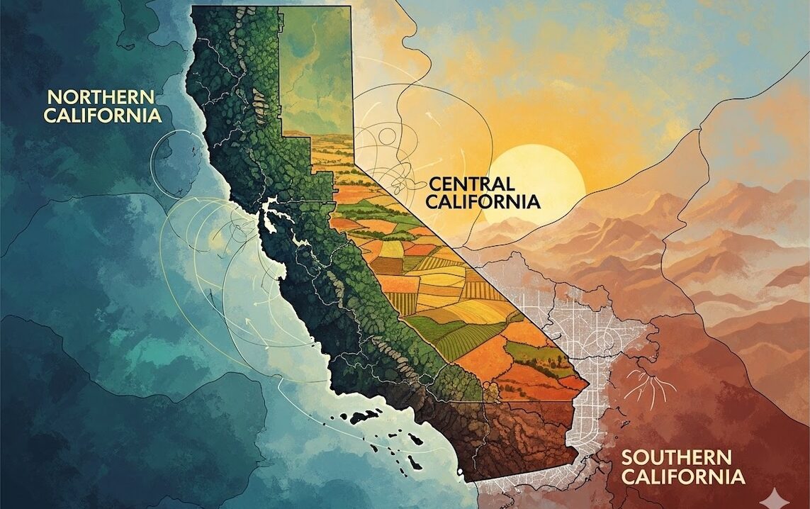
So two different people have made two different proposals for dividing the state, sharing the same line from Seal Beach to San Benito County. Why not combine the proposals, and “go on as three”? I can’t help but think of an old Jefferson Airplane song from 1970 that had those words in it, endorsing polyandry. But all the same, maybe three states is what is called for.
California North and California South will bear the zip code abbreviations CN and CS respectively, because NC and SC were already taken by two southeastern states under false pretenses. The third state could be Coastal California [CC] but that might be a bit offensive to the coastal stretches of CN and CS, which tend to be proud of their ‘coastal’ status. [Why I don’t know; the ocean is given by God, not achieved by human works.] More likely it will be California West, which will be abbreviated to CW and generally referred to as ‘Cee-dub.’ The reverse abbreviation, WC, is available, but it means ‘toilet’ in European English, and would consequently be a matter of great enjoyment to the inhabitants of the other two Californias.
Since CN gets Sacramento, the question of where the state capitals of CS and CW arises. For CW, San Luis Obispo is reasonably central, but I’m not sure that the locals will want the capital there. Monterey, having been one of the state capitals in Mexican times, may return to its capital status. The largest city in CS is San Diego, but it is so far off center to the state, and on the coast of a state mostly inland, so Riverside will probably emerge as the compromise location. [The Riverside-San Bernardino metro area is also bigger in terms of population than the San Diego metro area.]
Orange County will be in an odd position. It may rejoice in its political separation from LA, but only four roads cross the county line between it and the rest of CS; two freeways, the 91 and the 5, and two two-lane mountain roads, Carbon Canyon and Ortega Highway, are the only roads out of Orange County that don’t enter CW’s Los Angeles County. The Orange Countians will put up with this for the convenience of being in CS rather than CW, but it certainly rules out Santa Ana or Irvine as the state capital!
CW, as we see from the PPIC maps will be pretty much a one party state, but in Downtown Los Angeles and to the east and south sizable numbers of voters will buy into the Democrats’ fiscal agenda, but dissent from their social agenda. And since CW will have no Republicans to speak of, the social conservatives may have the courage to fight about it. CN will be predominantly liberal also, but perhaps with a little libertarian influence; hopefully as Bill Maze hoped, its policies will be friendlier to agriculture. CS will be predominantly conservative, with some dissent on fiscal policy in some areas and on social policy in others; San Diego will be the least reliable part of that state.
I have not taken the trouble, I admit, to count the various populations of CW, CN, and CS, and to estimate the number of congressional Representatives, and of electoral votes, each might have. It would be more interesting if I did.
I admit all this is a fantasy, and will never happen. But is the Internet not full of fantasies of this kind?
Related: “The State of Costal California” by Martin Lewis at NewGeography.com
Related: “‘South California’ proposed as 51st state by Republican supervisor” by Andrew Malcolm at LATimes.com