The ‘mean center of population’ gets a lot of publicity. But it is misleading, and it even misled me for 70 years. There is a less publicized ‘median center of population’ that is more useful for some purposes, like where the majority of the population actually lives.
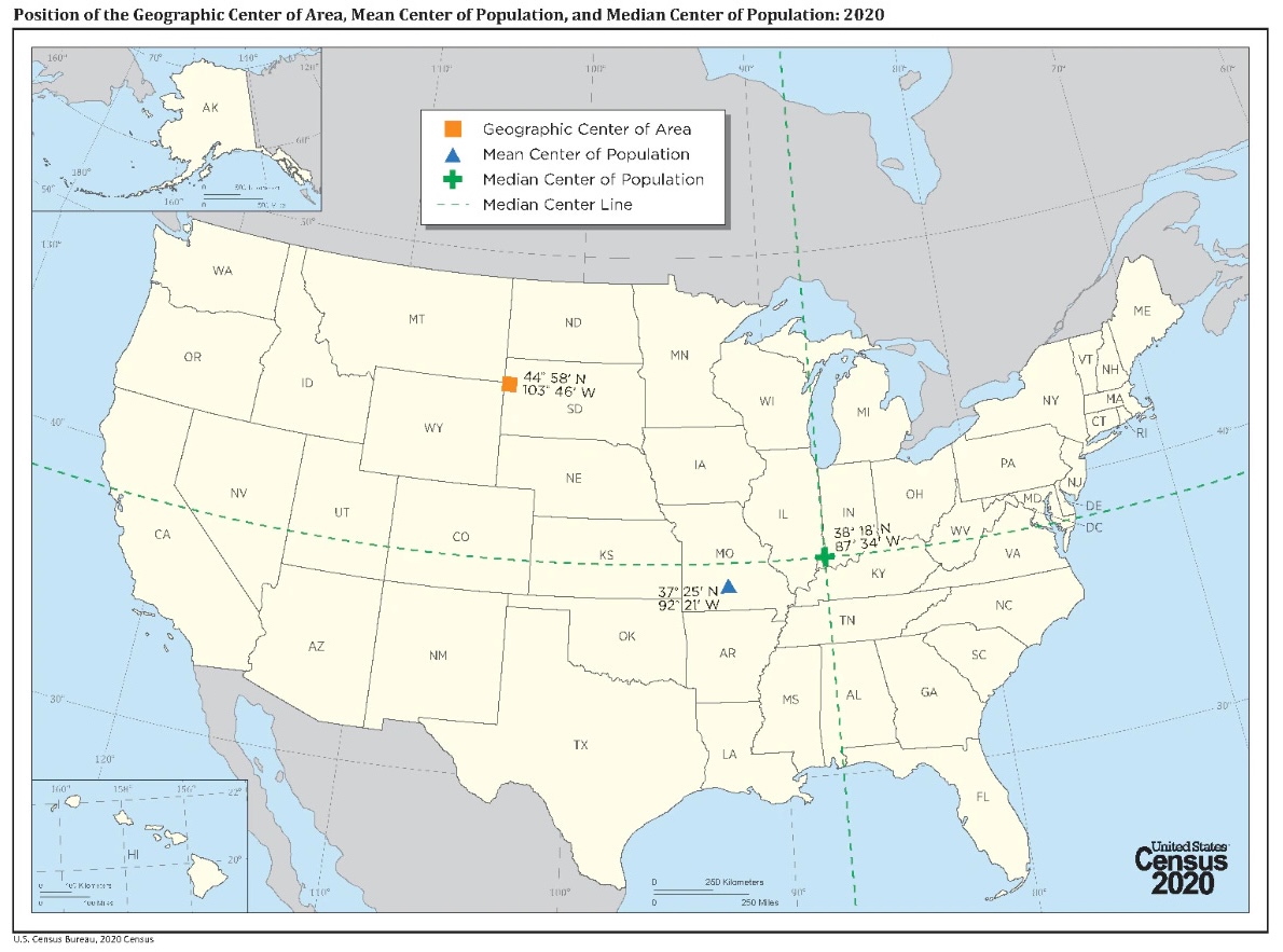
Much publicity is given, every ten years, to something called the mean center of population. This is the point at which the map of the United States would balance, if every person had equal weight. Since the 2020 census, this is now located at a place near Hartville, Missouri. The Census Bureau describes the mean ‘center of population’ this way:
If the United States map was a scale and every person had equal weight, the center of population is the place where the scale would balance. In other words, the center of population is the average location of where people in the United States currently live.
The first center of population, based on the 1790 census, was located in Chestertown, Maryland. Since then, the center of population has moved west and south.
The Census Bureau often promotes the ‘mean center’ of a population. For seventy years, I had been misled into thinking that this meant that half the population lived west of the mean center, and half lived south of it. Not so. Concerning the median center, the Census Bureau describes it this way:
A different center of population, the median center, can be computed by identifying the point through which a north-south line and an east-west line each divides the total population of the country in half. The Census Bureau computes this point after each census but does not report it as the official center of population for the United States.
. . . The median point, which may be described as the numerical center of population, is in no sense a center of gravity. In determining the median point, distance is not taken into account and the location of the units of population is considered only in relation to the intersecting median lines — as being north or south of the median parallel and east or west of the median meridian.
It is evident that extensive changes in the geographical distribution of the population may take place without affecting the position of the median point. In this respect, the median point differs essentially from the center of population, which responds to the slightest population change in any section of the country. To illustrate, assume the east-west population median meridian goes through St. Louis, Missouri. If a million persons moved from Kansas to California, the median point would not change, but the mean center of population would shift dramatically to the west [emphasis added].
The mean center of United States population may be in Missouri, but the median center, the place where half the population lives north of, half south, half east, and half west, is in southwest Indiana! So, half the population doesn’t live farther west than Hartville, Missouri – half of it lives farther east than a point in Southwest Indiana. And half of it lives farther north than this same point. These details help to explain why the Eastern United States still seems so dominant in the country at large. I had thought that half the population lived west of, and half of the population south of, Hartville, Missouri! It turns out that this is not so.
I think the median center of population of the United States, and also the median centers of the various states, deserve as much publicity and celebration as the mean center. For example, the mean center of population of California is near Shafter, northwest of Bakersfield. But on a Reddit post, there is a page which seems to say [it is a national map] that the median center of population in California is somewhere in West Los Angeles!
Knowing the median center gives you a much better idea of where the population is distributed than knowing the mean center only. I had, frankly, not understood myself that there is a considerable difference.